You picture mornings on the water and a boat at your back door, but planning a dock or seawall in the Florida Keys can feel confusing. Permits, surveys, and environmental rules stack up fast, especially around Key West. You want a clear path that protects your timeline and investment. In this guide, you’ll learn who approves what, which permits apply, how long reviews usually take, and the design choices that reduce headaches. Let’s dive in.
Who approves docks and seawalls in Key West
Several agencies may review your project, each with a different role:
- Monroe County handles local planning, zoning, shoreline standards, and building permits. Explore local requirements through the county’s Planning & Environmental Resources and Building Division pages.
- The Florida Department of Environmental Protection (FDEP) oversees activity on sovereign submerged lands and some environmental resource permits. Start with the Florida Department of Environmental Protection for state guidance.
- The U.S. Army Corps of Engineers (USACE) regulates structures and dredge or fill in navigable waters under Section 10/404. See the Jacksonville District’s Regulatory Program.
- The Florida Keys National Marine Sanctuary (FKNMS) protects seagrass, coral, and other sensitive resources. Many projects need a sanctuary authorization. Review the Florida Keys National Marine Sanctuary site for permits and rules.
- Florida Fish and Wildlife Conservation Commission (FWC) weighs in on protected species and may set seasonal work windows. Learn more at the Florida Fish and Wildlife Conservation Commission.
- The U.S. Environmental Protection Agency provides the Clean Water Act framework for dredge and fill. See the EPA overview of Clean Water Act Section 404 permits.
What permits you may need
Your exact approvals depend on scope and location. Common triggers include:
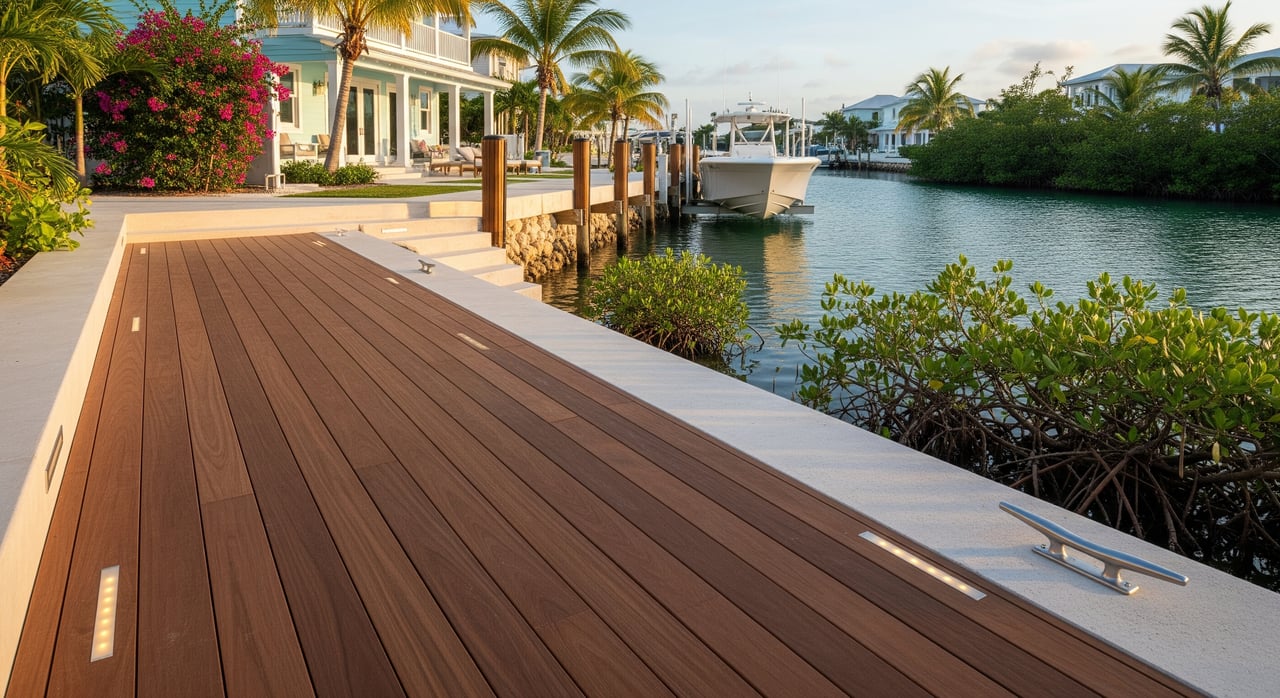
- New dock, pier, or boat lift that extends waterward of the mean high water line
- Seawall construction or replacement along the shoreline
- Dredging or placing fill below the water line
- Mangrove trimming or removal
Typical approvals and documents:
- Monroe County permits: Building permit with engineered plans, pile details, elevations, site plan, proof of ownership or riparian rights, and any tree or mangrove permits.
- FDEP authorizations: Use of sovereign submerged lands, and possibly an Environmental Resource Permit. Expect a project narrative, environmental resource surveys, and mitigation if impacts occur.
- USACE permits: Section 10 for structures in navigable waters and Section 404 for dredge or fill. You will likely need resource delineations, alternatives analysis, and mitigation plans if impacts are unavoidable.
- FKNMS authorization: Required where sanctuary resources could be affected. Submittals often include seagrass and coral surveys, construction methods, turbidity controls, and monitoring.
Common technical studies:
- Certified boundary and mean high or low water line survey
- Bathymetric or hydrographic survey for docks and any proposed dredging
- Submerged aquatic vegetation (SAV) and coral surveys with mapped locations
- Construction method statement and turbidity control plan
- Engineering drawings with cross sections, pile sizes, and materials
- Alternatives and mitigation plans
Key timelines and sequencing
Review times vary with complexity and completeness. Based on typical practice in the Keys:
- Pre-application coordination is strongly recommended. A short meeting with Monroe County and a pre-submittal discussion with FDEP, USACE, and FKNMS can prevent months of delay by confirming the correct permit path.
- General permits tend to move faster. For small, low-impact repairs that fit a general or programmatic permit, reviews can take weeks to a few months.
- Individual permits take longer. Projects with dredging, significant encroachments, or resource impacts often require 6 to 12 months or more across agencies.
- Plan for overlap. Many reviews run concurrently, but state authorization to use sovereign submerged lands is typically required before construction.
Common causes of delay include incomplete applications, missing surveys, unclear seagrass mapping, objections from neighbors, and the presence of coral or listed species that trigger extended consultation.
Florida Keys site constraints to plan for
The Keys are environmentally sensitive, and that shapes design and approvals:
- Seagrass beds are extensive and protected. Even small disturbances can require mitigation. Avoidance and light-permeable decking can help.
- Coral and hardbottom habitat carry strict protections. Where present, relocation is rarely simple and approvals can be limited.
- Mangroves are protected. Trimming or removal requires permits and specific methods, with potential replanting requirements.
- Water quality and turbidity controls are standard. Expect silt curtains and best practices during in-water work.
- Protected species like manatees and sea turtles may require seasonal work windows.
- Navigation and safety reviews ensure public access is not impaired.
- Resilience and sea level rise considerations influence long-term seawall and shoreline design.
Buyer and seller due diligence checklist
If you are buying or preparing to sell a waterfront home in Key West, collect and verify:
- Existing permits and approvals for docks, seawalls, dredging, or shoreline work, plus any as-builts
- Expiration or renewal conditions attached to prior permits
- Current boundary survey with mean high water line and any easements
- Title evidence of riparian rights and any recorded submerged-land leases or easements
- Environmental reports, including bathymetry, seagrass or coral surveys, and mangrove delineations
- FEMA flood zone and base flood elevation for the parcel
- Compliance history, including any notices, stop-work orders, or unresolved conditions
- Maintenance logs for docks and seawalls
- Insurance claims history and insurability of existing structures
- Estimates from licensed marine contractors and engineers, plus seasonal availability
- HOA restrictions or covenants affecting dock size or design
Suggested seller prep questions:
- Are current structures covered by active permits, and are they transferable?
- Were any structures built without permits or after permit expiration?
- Have neighboring projects affected navigation, shoreline stability, or access?
- Are there known seagrass, coral, or cultural resources in the project area?
Design choices that help approvals
You can reduce review time and risk with thoughtful design:
- Minimize the footprint waterward of the mean high water line
- Use pile-supported docks instead of solid fill structures when possible
- Avoid dredging; if unavoidable, document why no upland or alternative approach is feasible
- Choose light-permeable decking to reduce shading impacts on seagrass
- Maintain safe navigation clearances and avoid obstructing public access
- Plan construction to limit turbidity and avoid sensitive seasons
- Engage a local marine engineer and environmental consultant early
- Document pre-construction conditions with photos and surveys
Budget drivers and common risks
Costs and risk vary with scope and site conditions. Key drivers include:
- Scope and impact level: repair versus replacement, and whether dredging is involved
- Submerged resources: seagrass, coral, or hardbottom often add mitigation and monitoring costs
- Permit pathway: general permits are typically faster and less expensive than individual permits
- Surveying, engineering, and environmental consulting needs
- Mitigation requirements or credits for unavoidable impacts
- Contractor demand and seasonality in the Keys
- Long-term maintenance for piles, decking, hardware, and seawall tiebacks
Risks to flag early:
- Unpermitted structures that need retroactive approval or removal
- Dense seagrass or coral that makes approval unlikely or cost prohibitive
- Open enforcement actions or unresolved permit conditions
- Evolving rules and resilience standards that affect design
- Sea level rise and storm surge that can challenge shoreline solutions over time
A practical planning checklist
Use this as a quick-start roadmap:
- Schedule a pre-application conversation with Monroe County and discuss your concept with FDEP, USACE, and FKNMS staff.
- Order a current boundary survey with mean high water line and a bathymetric survey, if relevant.
- Commission seagrass and coral surveys to map resources accurately.
- Work with a marine engineer on a minimal-impact design that maintains navigation and reduces shading.
- Prepare a construction method statement with turbidity controls and seasonal windows.
- Assemble complete applications for county, state, federal, and sanctuary authorizations.
- Budget time for general permits to take weeks to a few months, and individual permits to take 6 to 12 months or more.
- Line up licensed marine contractors early and plan for Keys seasonality.
- Build mitigation and monitoring contingencies into your budget.
- Keep thorough records and photos before, during, and after construction.
Let’s connect early
If you are considering a waterfront purchase or planning improvements in Key West, I will help you structure due diligence, align your timeline with likely approvals, and connect you with experienced marine engineers and contractors. Schedule a free consultation and let’s build a clear plan before you buy or start design.
FAQs
Do I need a permit to build a dock in Key West?
- Yes. Local Monroe County approvals apply, and most projects also require state authorization from FDEP and federal review by the USACE; many sites within the Florida Keys National Marine Sanctuary need sanctuary authorization as well.
How long do dock or seawall permits take in the Florida Keys?
- Simple projects that qualify for general permits often take weeks to a few months, while individual permits with resource impacts typically range from 6 to 12 months or longer.
Who controls the seabed under my proposed dock in the Keys?
- Lands waterward of the mean high water line are typically sovereign submerged lands managed by the State of Florida, so FDEP authorization to use those lands is usually required.
Can I trim mangroves to improve boat access in Monroe County?
- Trimming or removal of mangroves is regulated at the local and state levels, requires permits, and must follow strict methods; replanting or mitigation may be required.
Is dredging allowed near my home in Key West?
- Dredging triggers USACE Section 404 review and state authorization, often with additional sanctuary coordination; approvals can be difficult where seagrass or coral are present and may require significant mitigation.
What surveys should I order before designing a dock in the Florida Keys?
- A current boundary survey with the mean high water line, a bathymetric or hydrographic survey as needed, and submerged aquatic vegetation and coral surveys to map sensitive resources accurately.